Posts

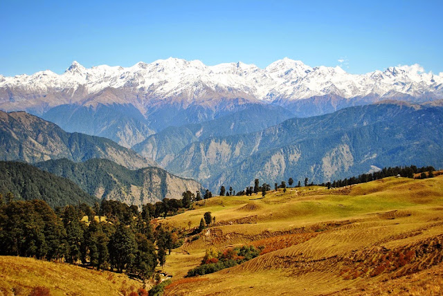
Harsil : paradise village

Image
Harsil is a village and a cantonment area on the banks of the Bhagirathi River, on the way to the Hindu pilgrimage, Gangotri, in Uttarkashi district of the Indian state of Uttarakhand ). Situated at a height of 7,860 ft (2,620 metres.) from sea level, Harsil lies 73 km. from Uttarkashi, and 30 km away from Harsil, lies the Gangotri National Park, spread over 1,553 square km.                                                                 image source                                                                 image source                                                                         image sorce

high altitude meadow "Dayara Bugyal"

Image
Dayara Bugyal, in Uttarkashi district, meaning "high altitude meadow" is at an elevation of 3,408 metres (11,181 ft). The beautiful meadows are developed into ski slopes covering an area of 28 square kilometres (11 sq mi). It has also been planned as a skiing resort. It is approached from Uttarkashi, up to village Barsu by road and further 6 kilometres (3.7 mi) by trekking.                                                                          Image Source                                                        Image Source                                                                    Image source

Har Ki Doon, Uttarkashi

Image
Har Ki Doon Valley is a cradle shaped hanging valley in the Garhwal Himalayas. It is surrounded by snow-covered peaks and alpine vegetation. It is connected to Baspa Valley by the Borasu Pass. Har Ki Doon is a very popular place among trekkers. The best way to reach this place is from Mussoorie through Yamuna Bridge, Naugaon, Purola, Saur, Sankri, Taluka and Osla.    Har Ki Doon has bungalows as well as rest houses for trekkers, located at an altitude of 3506 m Image Images

Khardungla Pass: Highest civilian motor road in the world (Myth or Truth)

Image
Khardung La is a mountain pass located in the Ladakh region of the Indian state of Jammu and Kashmir. The local pronunciation is "Khardong La" or "Khardzong La," but, as with most names in Ladakh, the romanised spelling varies. In Summer ( image  source) Khardung La is at times incorrectly cited as the highest vehicle-accessible pass in the world. A well-graded Indian military road (visible on 2011 imagery on visual globe systems such as Google Earth) reaches 5,610 metres (18,406 ft) 250 meters west of the 5,545 metres (18,192 ft) Mana Pass on the India - Tibet border. Image   source Image  source 

Suru Valley: The trek to the Drang Drung glacier

Image
The trek through Suru Valley to the Drang Drung glacier is one of the best in this aspect offering a mix of all the possible things one may do on the mountains. The trek is among one of the tough ones in the region and is only taken up by the experienced trekkers. Image                                                                                Image                                                                                                                 Image 

Nubra Valley: A desert among the snowy hills

Image
Nubra is a tri-armed valley located to the north east of Ladakh valley. Diskit the capital of Nubra is about 150 km north from Leh town, the capital of Ladakh district, India. Local scholars say that its original name was Ldumra (the valley of flowers). The Shyok River meets the Nubra or Siachan River to form a large valley that separates the Ladakh and Karakoram Ranges. The Shyok river is a tributary of the Indus river. The average altitude of the valley is about 10,000 ft. i.e. 3048 metres above the sea level. image image image

Tso Moriri lake, Laddakh

Image
Tso Moriri or Lake Moriri Tibetan: , is a lake in the Ladakhi part of the Changthang Plateau (literally: northern plains) in Jammu and Kashmir in northern India. The lake is at an altitude of 4,522 m (14,836 ft). It is the largest of the high altitude lakes entirely within India and entirely within Ladakh in this Trans-Himalayan biogeographic region. The official name of the land and water reserve here is the Tso Moriri Wetland Conservation Reserve. image image image